Who among Russian scientists explored Africa. Geographical position. African studies
In this article, we recall the contribution that researchers from Africa have made to the development of geography. And their discoveries completely changed the perception of the Black Continent.
Africa's first research
The first known journey around the African continent was made as early as 600 BC. e. researchers of ancient Egypt on the orders of Pharaoh Necho. The pioneers of Africa circled the continent and discovered uncharted lands.
And in the Middle Ages, this part of the world began to arouse serious interest in Europe, which led active trade with the Turks, reselling Chinese and Indian goods at a huge price. This prompted European mariners to try to find their own way to India and China in order to exclude the mediation of the Turks.
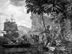
Researchers from Africa appeared, and their discoveries significantly influenced world history. The first expedition was organized by the Portuguese Prince Henry. During the first voyages, the sailors discovered Cape Boyador, which is located on the west coast of Africa. The researchers decided that this is the southernmost point of the mainland. Modern scholars believe that the Portuguese were simply afraid of the dark-skinned Aborigines. Europeans believed that the sun was hanging so low above the new land that the locals burn to black.
The Portuguese king Juan II outfitted a new expedition, led by Bartolomeo Diaz, and in 1487 the Cape of Good Hope was opened - the real southern point of the mainland. This discovery helped the Europeans pave the way for eastern countries. In 1497-1499, Vasco Da Gama first reached India and returned to Portugal.
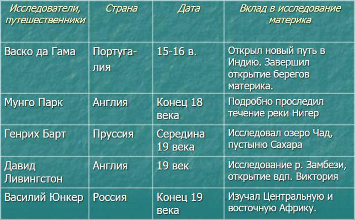
To systematize the knowledge gained will help the table "Researchers of Africa", located below.
After this discovery, the Europeans poured into Africa. In the 16th century, the slave trade began, and by the 17th most of the territories of the black continent were seized and colonized. Only Liberia and Ethiopia have retained their freedom. In the 19th century began an active study of Africa.
David Livingstone
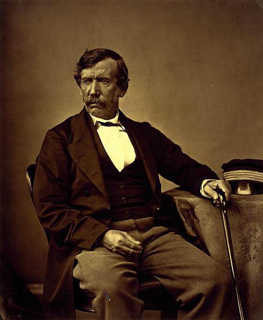
The scientist also explored Lake Ngami, described the tribes of Bushmen, Baclahari and Macololo, and also discovered Lake Dilolo, the western drain of which feeds the Congo and the eastern Zambezi. In 1855, a huge waterfall was opened, which is named after the British Queen Victoria. Livingston became very sick and disappeared for a while. He was discovered by the traveler Henry Morton Stanley, and together they explored Lake Tanganyika.
The researcher devoted most of his life to Africa, was a missionary and humanist, tried to stop the slave trade. A scientist died during one of the expeditions.
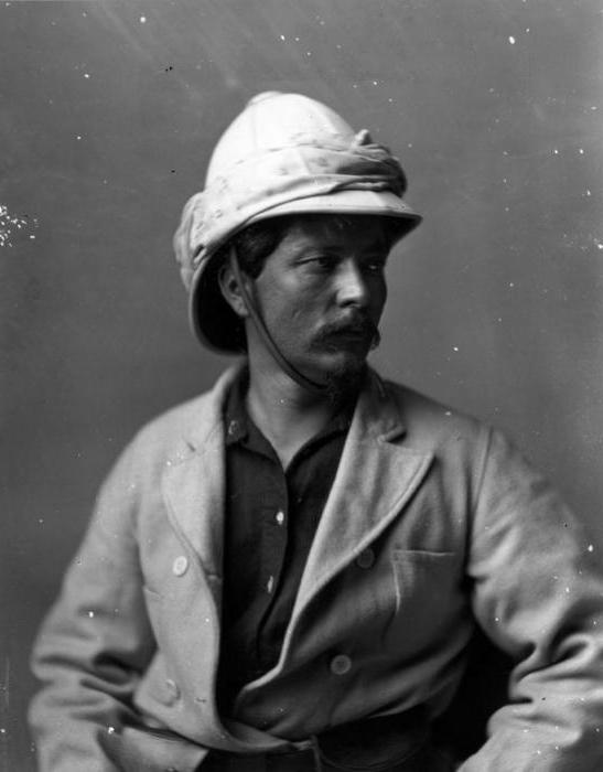
Mungo Park
Mungo Park embarked on two expeditions to the Black Continent. Its purpose was to study West Africa, mainly its interior, sources and Sinegal. Also, the desired goal was to establish the exact location of the city of Timbuktu, which the Europeans had until this moment only heard from local residents.
The expedition was sponsored by Joseph Banks, who participated in the first journey of James Cook. The budget was quite modest - only 200 pounds.
The first expedition was undertaken in 1795. It began at the mouth of the Gambia, where then there were already English settlements. From one of them, a researcher with three assistants went up the Gambia. In Pisania, he was forced to stay for 2 months, as he contracted malaria.
Later, he went further up the Gambia and along its tributary Neriko, along the southern border of the Sahara, where he was captured. A few months later, the scientist managed to escape and reach the Niger River. Here he made a discovery - Niger is not the source of the Gambia and Senegal, although before that the Europeans believed that it was divided. For some time, a researcher travels around Niger, but falls ill again and returns to the mouth of the Gambia.
The second expedition was better equipped, it was attended by 40 people. The goal was to explore the Niger River. However, the trip was unsuccessful. Due to diseases and clashes with local residents, only 11 people were able to get to Bamako alive. Park continued the expedition, but before sailing sent with the assistant all his records. African researchers may not always return home from dangerous places. Park was killed near the city of Busa, fleeing from the locals.
Henry Morton Stanley
Henry Morton Stanley, an English researcher in Africa, is a famous traveler and journalist. He went in search of the missing Livingstone, accompanied by a detachment of natives, and found him seriously ill in Ujiji. Stanley brought some medicine with him, and soon Livingston was getting better. Together they explored the north bank of Tanganyika. In 1872, he returned to Zanzibar and wrote the famous book “How I Found Livingstone.” In 1875, accompanied by a large group of scientists reached Lake Ukereve.
In 1876, with a detachment of 2,000 people, who were equipped by the king of Uganda, Henry Morton Stanley made a great journey, corrected a map of Lake Tanganyika, discovered Lake Albert Edward, reached Nyangwe, explored the River Lualaba and ended the expedition to the estuary. Thus, he crossed the mainland east to west. Journey scientist described in the book "Through the Black Continent."
Vasily Junker
Russian researchers in Africa have made a great contribution to the study of the Black Continent. Vasily Junker is considered one of the largest explorers of the Upper Nile and the northern part of the Congo Basin. He began his journey in Tunisia, where he studied Arabic. The object of study, the scientist chose equatorial and eastern Africa. He traveled the Libyan desert, the rivers Baraka, Sobat, Role, Jute, Tonji. Visited the country Mitta, Kalika.
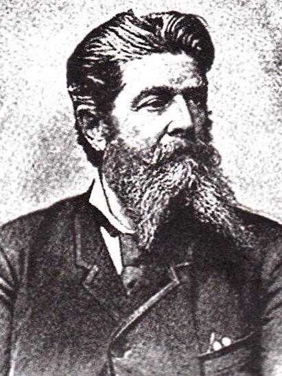
Juncker not only collected a rare collection of representatives of flora and fauna. His cartographic studies were accurate, he compiled the first map of the Upper Nile, also the scientist described the flora and fauna, especially the great apes, discovered an unknown animal - a six-winged. The ethnographic data collected by Juncker is also valuable. He compiled dictionaries of Negro tribes, collected a rich ethnographic collection.
Yegor Kovalevsky
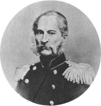
African explorers arrived on the continent and at the invitation of local authorities. Egor Petrovich Kovalevsky asked the local viceroy Scientist to come to Egypt. He conducted various geological studies in northeastern Africa and discovered loose gold deposits. He was one of the first to indicate the position of the source of the White Nile, studied in detail and mapped a large territory of Sudan and Abyssinia, described the life of the peoples of Africa.
Alexander Eliseev
Alexander Vasilievich Eliseev spent several years on the continent, from 1881 to 1893. He explored northern and northeastern Africa. He described in detail the population and nature of Tunisia, the coast of the Red Sea and the lower reaches of the Nile.
Nikolay Vavilov
Soviet researchers in Africa often visited the Black Continent, but Nikolai Ivanovich Vavilov is the most prominent among them. In 1926 he made the most important expedition for science. He explored Algeria, the Biskra oasis in the Sahara desert, the mountainous region of Kabiliya, Morocco, Tunisia, Somalia, Egypt, Ethiopia and Eritrea.
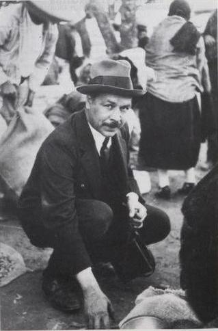
Botany was primarily interested in the appearance of cultivated plants. He devoted much time to Ethiopia, where he collected more than six thousand samples of cultivated plants and found about 250 species of wheat. In addition, a lot of information was obtained about the wild representatives of the flora.
Nikolai Vavilov traveled around the world, exploring and collecting plants. On his travels, he wrote the book "Five Continents".
The first journey around Africa was initiated by the Egyptian pharaoh Necho in 600 BC. The ancient Egyptians managed to travel around the continent and discover new lands.
In the Middle Ages, Africa aroused interest among Europeans. In those days, the Europeans were active in trade with the Turks, who resold to the west oriental spices and textiles.
At that time, all oriental goods were incredibly expensive, and European mariners decided to independently find a sea route to China and India in order not to use the mediation of the Turks.
Expeditions of Henry the Navigator
The first expeditions to Africa were organized by the Portuguese Prince Henry. During the first Portuguese expeditions, Cape Boyador was discovered, located on the west coast of the African continent.
The Portuguese made the false conclusion that this cape is the southernmost point of the mainland. There are historical sources by which it can be judged that the Portuguese navigators simply frightened the appearance of the aborigines, and did not continue their expeditions.
Europeans believed that in Africa the sun is so close to the ground that the locals sunbathe their daughter.
Discovery of the Cape of Good Hope
After the death of Prince Henry, his work was continued by the Portuguese king Juan II. He sent a new expedition to Africa, led by Bartolomeo Diaz in August 1487.
It was during this expedition that the southernmost point of the continent was reached - the Cape of Good Hope. This name was given to the Cape by the Portuguese monarch, since such a discovery paved the way for Europeans to India and China.
New discoveries, the beginning of colonization
After the successful expedition of 1487, after the Portuguese, other Europeans began to actively invade Africa. Until the beginning of the 16th century, the Spaniards, the British, and the Portuguese discovered all the territories of the west coast of Africa.
By the middle of the 16th century, an active slave trade was launched. In the eyes of Europeans, Africa looked like a rich source of natural and human resources. Successes in the slave trade prompted the Europeans and the Ottomans to colonize Africa. By the beginning of the 17th century, all of North Africa was under the control of the Ottoman Empire.
The European states that entered the industrial era, by the mid-19th century, divided the whole territory of Africa among themselves. Only two African states (Ethiopia and Liberia) were able to maintain their independence and were not included in the metropolitan area.
Need help learning?
Previous topic: The geographical position of Africa: general characteristics and featuresNext topic: & nbsp & nbsp & nbsp Features of the relief of Africa: mountains and lowlands of the region
13.04.2016
The African continent was the last (mastered and colonized by Europeans) part of the earth’s land. And it happened only in the XIX century. Close to Europe, Africa for a long time practically did not interest experienced seafarers of the main maritime powers - Portugal, Spain, Holland, Great Britain, France. Fascinated by the legends about the treasures of Asia, they were not interested in the territory where the Carthaginians ruled first, then the Romans, and after them the powerful Arabs.
Therefore, until the 15th century, only Muslim travelers were engaged in the study of Africa, especially its inland areas — first the subjects of the Arab Caliphate and then the Ottoman Empire. On the European maps of that time, the southern part of Africa was depicted either too small - up to the equator, or connected to the southern mainland - the mythical Terra Australis incognita.
The great voyages in search of a sea route to India forced us to pay attention to Africa. From the beginning of the 15th century, the Portuguese began to try to clarify the length of the continent, for which they sent numerous expeditions, increasingly moving away from the Iberian Peninsula. Their organization was led by the Portuguese Infant Enrique (Heinrich), who was later named the Navigator for his services in establishing sea voyages along the West African coast.
Thanks to the financial support of Heinrich the Navigator, the Portuguese, starting in 1415, were able to advance to southern Africa. Until finally, in 1488, Bartolomeu Dias reached the Cape of Good Hope, beyond which the coastline turned to the northeast. Ten years later, another Portuguese - Vasco da Gama was able to pass along the eastern coast of the mainland, cross the Indian Ocean and get into the coveted India.
However, the search for the southern tip of Africa and the study of its shores were conducted not only for this purpose. Enrique was also interested in trade with the peoples of Africa, which he wanted to bypass the Arabs. His vigorous activity bore fruit - until his death in 1460, he actually laid the foundation of the colonial power of Portugal. Moving along the African coast, the Portuguese landed and contacted the local population, trading and exchanging goods.
Penetration into the depth of AFriki happened slowly and, first of all, along the river valleys. It began in the years 1455-1456 from the valley of the Gambia River, along which the Italians da Kadamosto and Uzodimare passed, serving Prince Enrique. In the years 1482-1485, the ships of Diogo Kahn twice climbed the Congo River at 100 and 150 km. However, the study of land sites remote from the ocean was practically not conducted until the XIX century. Although the African coast was controlled by the Portuguese since the 17th century, other European nations also began to show interest in this continent.
The end of the 18th and 19th centuries was marked by several large expeditions and the names of travelers who visited various parts of the mainland. Mungo Park, a Scotsman and educational surgeon, visited Africa twice, both times at the invitation of the African Association, established in London in 1788. On the first trip, his goal was to reach the headwaters of the Senegal and Gambia rivers and find the legendary city of Timbuktu.
The park managed to reach the southern border of the Sahara and investigate the course of the Niger River, to visit the Moors in captivity, to fall ill several times with fever, but nevertheless, to return home alive. He received a proposal for participation in the new expedition in 1805 and accepted it enthusiastically. 40 people went to explore the Niger Valley, of which only 11 were able to reach the capital of Mali. On the way back, Mungo Park died in a skirmish with the Moors, but his diaries, previously submitted to the conductor, were returned to their homeland.
In 1842-1847, the German naturalist Wilhelm Peters conducted a pre-planned study of the nature of Africa. He visited Angola, Mozambique, Zanzibar, Madagascar and the Comoros, brought a large collection of samples to Berlin and published a four-volume work about his trip. By the way, Peters was a foreign corresponding member of the Russian Academy of Sciences.
Another German, the geographer Heinrich Barth, in 1845 set out from Tangier and crossed the whole of North Africa by land, and in 1850 participated in the expedition of the Briton James Richardson, a Sahara explorer. Bart was very interested in the culture and history of Africa, knew the Arabic language and was able to independently establish contacts with some Muslim scholars.
One of the most famous explorers in Africa was the Scot David Livingstone (1813-1873), who devoted most of his life to this continent and died during one of his travels in the territory of modern Zambia. He crossed the Kalahari Desert, explored the lakes Ngami, Dilolo and Tanganyika (the latter - together with Henry Morton Stanley), discovered the Victoria Falls.
Among Russian scientists of the 19th century, Vasiliy Junker, Yegor Kovalevsky, Alexander Eliseev visited the African continent with expeditions. From 1885 to 1900, a real battle for African lands began between European countries, the military and research teams were sent to the continent one by one. As a result of this, by the beginning of the 20th century Africa was not only considerably studied, but completely divided and colonized.
Page 1
Initial Study of Africa
(2nd millennium BC. - up to 6.).
The beginning of the study of Africa belongs to antiquity. The ancient Egyptians mastered the northern part of the continent, moving along the coast from the mouth of the Nile to the Gulf of Sidra, penetrated the Arabian, Libyan and Nubian deserts. About 6 in. BC e. Phoenicians made long voyages around Africa. In the 6th century BC e. Carthaginian Gannon navigator undertook sailing along the west coast of the continent. According to the record on the slab he left in one of the temples of Carthage, he reached the inside of the Gulf of Guinea, where the Europeans had penetrated almost two thousand years later. During the period of Roman rule and later fishing vessels reached the Canary Islands, Roman travelers penetrated deep into the Libyan desert (LK Balb, S. Flaccus). In 525 the Byzantine merchant, navigator and geographer Kozma Indicoplov climbed up the Nile River, crossed the Red Sea and toured the coast of East Africa. He left a 12-volume work, which served as the only source of information about the Nile River and adjacent territories for its time.
The second stage of the study of Africa - the Arab campaigns (7-14 centuries).
After conquering North Africa (7th century), the Arabs crossed the Libyan desert and the Sahara desert many times, began to explore the Senegal and Niger rivers and Lake Chad. In one of the earliest geographic reports of Ibn Hordadbeh in the 9th century. contains information about Egypt and trade routes to this country. At the beginning of the 12th c. Idrisi showed North Africa on the world map, which by accuracy was significantly superior to the maps then existing in Europe. Ibn Battuta in 1325-49, coming out of Tangier, crossed north and east Africa, visited Egypt. Later (1352-53) he passed the Western Sahara, visited the city of Timbuktu on the Niger and then returned back through the Central Sahara. The essay he left contains valuable information about the nature of the countries he visited and the mores of the peoples inhabiting them.
The third stage of the study of Africa - travel 15-17 centuries.
In 1417-22, the Chinese naval commander Zheng He, in one of his many hikes, passed the Red Sea, rounded the Somali Peninsula and, moving along the east coast, reached the island of Zanzibar. In the 15-16 centuries. the study of Africa was associated with the search of the Portuguese sea route to India. In 1441 N. Trishtan reached Cape Cap Blanc. D. Dias in 1445-46 skirted the extreme western point of Africa, which he called the Cape Green. In 1471, Fernando Po discovered the island, named after him. In 1488 B. Dias discovered the extreme southern point of Africa, calling it the Cape of Storms (later renamed the Cape of Good Hope); in 1500, not far from this cape during the storm B. Dias died. Based on the reports of B. Dias, the route to India was developed by the Portuguese navigator Vasco da Gama. In 1497-98, he, going to India from Lisbon, rounded the Cape of Good Hope and passed along the east coast to 3 ° 20 "S lat. (City of Malindi). In 1487-92 P. Covilha traveled from Lisbon through the Mediterranean Sea to the Nile estuary, and then passed along the southwestern coast of the Red Sea to the city of Suakin. ) and Nyasa (1616), investigated the origins of the Blue Nile and the lower course of the Congo River. In the west In the 17th century, the French expedition of A. Bru explored the Senegal River, the English expedition - the Gambia River.
The fourth stage of the study of Africa - the expedition 18-20 centuries.
From the end of the 18th century the desire to master new rich sources of natural resources stimulated the study of Africa by British, French and German travelers. Expeditions concentrate in the interior of the continent. The British create a special "Association to promote the discovery of the interior of Africa", which organized a number of important expeditions. M. Park in 1795-97 and 1805-06 studied the upper reaches of the Niger River, U. Audney, D. Denham and H. Clapperton in 1822-23 crossed the Sahara from north to south (from the city of Tripoli to Lake Chad) and proved that the river Niger does not originate from this lake. The passage through the Sahara in 1827-28 was made by the French traveler R. Kaye. In 1830, the British expedition studied the lower reaches and the mouth of the Niger River (R. Lender and D. Lender).
At the end of the 18th - first half of the 19th century. The study of South Africa begins, the first explorer of which was the English traveler J. Barrow. In 1835, E. Smith surveyed the Limpopo River; in 1868, S. Ernskain passed along its tributary, the Olifants.
Geographical and geological study of the Blue Nile basin was carried out in 1847-48 by a Russian expedition of E. P. Kovalevsky, the first Russian traveler to describe Abyssinia. In the middle of the 19th century French (A. Lenan de Belfon and D Arno) and German expeditions (F. Vernet) worked in the White Nile basin. The highest point of the continent was Kilimanjaro volcano opened in 1848-49 by German missionaries I. Krapf and I. Rebman. English expedition J. Spika and R. F. Burton discovered Lake Tanganyika in 1856–59. In 1858 Lake Victoria was discovered by J. Speke, who later (1860–63) established together with J. Grant that the Nile River originated from this lake.
Brief description of the region
The Irkutsk Region is located in the south of Eastern Siberia, bordered by the Krasnoyarsk Territory, the Chita Region, the Republic of Buryatia, the Republic of Tyva and the Republic of Sakha (Yakutia). Territory - 767.9 thousand square meters. km (4.5% of the area of Russia). The population is 2,712.9 thousand people (1.9% of the population of Russia). Major minerals ...
Global problems of landscape differentiation
The geographical sphere is divided into different ranks of natural complexes as a result of the impact of four main groups of factors. Cosmic factors - the position of the Earth in the Solar System, the insolation of the spherical surface of our planet with daily and annual movements, the transformation of the solar ...
Climatic features
The Omsk Region has unique natural and climatic conditions: picturesque landscapes, lakes, forests, natural healing springs. The territory of the region, over 600 kilometers from north to south, is located in several natural complexes: complete taiga, small-leaved forests, northern and southern ...
H
beginning in 1802, Portuguese wandering merchants (Pombeiros) crossed the African continent in the southern hemisphere on the way from Angola to Mozambique and in the opposite direction. At the same time, most of the way they traveled through the extensive slave-owning state of Lund (aka Mwato-Yamvo), stretching from the headwaters of the Zambezi and Kasai, the greatest (about 2000 km) left Congo tributary, in the west to Lake Mweru, lying near the south-west corner of Lake Tanganyika in the east. Although by that time the state of Lund was in decline and actually disintegrated into several separate “kingdoms” (for example, “Kazembe”), there was still a lively domestic and foreign trade with coastal countries. The names (but not surnames or nicknames) of two Pombeiruses, in 1802–1811, reached our time. completed the second (after the priest Ataydi) crossing the continent. The story of these illiterate merchants - Pedro Juan Baptisht and António Jose - was recorded by colonial officials and subsequently published. Of the rather fragmentary and inconsistent information, it is now possible to outline their approximate route. In November 1802, they headed north-east from the lower Kwanza River. For an imperceptible watershed, they crossed the river. Kwango and in the basin of the river. Quilu traded for two years. Then crossed the river. Kasai and lingered on the right bank for some time, not going south of 8 ° S. sh. At the end of May 1806, they moved to the southeast, successively forced Lubilash, Lufira and Luapulu, i.e. the upper reaches of the r. Congo, reaching in December 1806 to the area where the rivers flowed mainly in a southerly direction (the basin of the middle Zambezi). Because of the war, they lived there for four years and only at the beginning of February 1811 arrived in Tete, on the lower Zambezi. In 1815, Pombeirous returned to Angola.
In 1831–1832 a Portuguese reconnaissance military unit under the command of a major penetrated into "Kazembe" from Mozambique Jose Monteiro, discovered on the way there Lake Mweru (5100 km ²). His companion captain António Gamitu, made a report on this expedition, but in Europe they paid attention to it only in the 70s. XIX century, after great journeys D. Livingstonewhen the London Geographical Society published a book about the “Country of Kazemba” (1873). The story of Gamitu about the magnificent courtyard of the country's ruler is given in extracts from B. Davidson's “The New Discovery of Ancient Africa”. M., 1962. In 1852, a group of Arab merchants returning home on Fr. Zanzibar, joined the colonial official and merchant António Francisco Silva-Porto. They left the Atlantic port of Benguela, crossed the mainland eastward, rounding Lake Nyasa from the south, and reached the r. Ruvumy; along it in 1854 they descended to the Indian Ocean, completing the crossing of Africa. Silva-Porto delivered the scant news of pp. Kafue and Lwangwe and the tribes that inhabited the basins of these large left tributaries of the Zambezi.
Have
private soldier of the war with kafira army captain James Edward Alexander (later received an "addition" to the last name: of-Westerton) led a small detachment to explore the territory north of the Cape of Good Hope. With seven satellites, he set off in September 1836, crossed the river. Orange in the lower reaches and explored the small mountains Karasberg, from which originate the numerous drying rivers of the Orange system, including its large influx of fish with their “satellites”. Forcing Fish at 27 ° Yu. sh., Alexander proceeded upstream of its tributary Konkip and familiarized himself with the mountain uplifts of the Big Namaqualand, including the Schwarzrand. At the Southern Tropic, having passed a series of temporary rivers lost in the Namib Desert, the detachment reached the “normal” Keiseb River, which flows into the Whale Bay, and along its valley in mid-April 1837, descended to the ocean coast.
In early May, Alexander moved back up the river. Keyseb, described part of the Damaraland mountain structures and returned to the Cape on September 21, having covered more than 2.3 thousand km in a previously unexplored area. D. Arrowsmith used the topographic materials collected by Alexander to compile the first reliable map of South-West Africa, which was the only one for a long time. Alexander first reported reliable ethnographic information about the Hottentots of Nama and Herero (Damara) and compiled a dictionary of the hitherto unknown language Herero.
Hungarian naval officer Laszlo Magyarwho served in the fleets of three countries (Austria-Hungary, Argentina and Brazil), after visiting on duty the r. Congo in 1848 "fell ill" with Africa and decided to study the depths of its interior. At the end of 1848, he landed in Benguela and in January of the following year moved eastward, between the headwaters of the Cubango (Okavango) and Kvanza. Here, in the village of Bie, he quickly found a "common language" with one of the leaders, marrying his daughter; The dowry of his wife (armed slaves - hunters) greatly helped Madiyar in his further research activities.
In 1850, Magyar made a speech from the Bie which had become his native to the northeast in a table-like country. Touching p. Kasai, near the source (then, obviously, did not know to which basin this largest tributary of the Congo belongs), it passed down the river valley to about 6 ° 30 "S, i.e., traced about 1 thousand km of its currents. Returning home, the Magyar crossed the headwaters of the Lulva River, a large tributary of the Kasai, then crossed over successively all the rivers flowing into the upper Zambezi, including the Lungwebungu, on the right, just south of this river and in 1851 arrived in Biya According to the materials of the route, he had the correct idea of a significant parts of the Kasai (Congo) - Zambezi watershed as a huge flat plain, which he was the first to explore.
In 1852-1853 he explored the north-western outskirts of the Kalahari and r. Kunene from headwaters to the middle reaches, where she, in his words, had a majestic appearance. Although the health of the Magyar all deteriorated, in 1855 he continued to study the hydrography of Angola, passing along the river. Kubango about 1 thousand km to the confluence of the river. Quito. He first found out: Kubango (length 1600 km, as established later) originates on the plain (Bié plateau), not far from the sources of the r. Kunene, and not associated with it. Magyar figuratively called this hydrographic site the “mother of South African waters” and for the first time inspected and correctly mapped almost the entire (about 800 km) watershed pp. Zambezi, Congo and Kwanza.
D
David Livingstonea native of a very poor Scottish family, he worked in a weaving factory at the age of ten and attended college after a fourteen-hour working day. Due to lack of funds, he entered the service of the London Missionary Society and was sent as a doctor and missionary to South Africa. From 1841, Livingston lived at the mission (at 27 ° S. Sh.) In the mountainous area of Kuruman, Bechuan country. He was well trained in their language (the Bantu family), and this helped him a lot during his travels, since the Bantu languages are close to each other, and he, as a rule, did not need a translator. He married Mary Moffetthe daughter of a local missionary Robert moffetta, the first explorer of the vast Kalahari semi-desert; and his wife became his faithful Assistant. For seven years, Livingston spent in the Bechuan country. Under the pretext of organizing a mission station in the northern areas of the territory under his control, he usually made a number of journeys in the winter.
In 1849, Livingston became interested in the stories of Africans about the "beautiful and extensive" Lake Ngami. He crossed from south to north of the Kalahari to 21 ° S. w., having established that it has a very flat surface, cut through by dry river beds, and is not at all as deserted as previously thought. In August, Livingstone carried out a study by the Ngami, which turned out to be a temporary lake, feeding during the rainy period by the waters of the great Okavango River, through the drying arms of its marshy delta. In June 1851, after passing to the northeast of the Okavango swamp on the territory infected with the tsetse fly, he first reached the r. The Linyanti (lower Kwando, the largest right tributary of the Zambezi) and in the village of Sesheke (around 24 ° E) enlisted the help of the leader of the powerful Makololo tribe.
In November 1853, with a detachment of 160 makololo on 33 boats, Livingston began sailing up the Zambezi across a flat, savanna-covered plain, sometimes overcoming rapids. Most of the people he let go on the road. By February 1854, with a small detachment, he had risen along the river to its upper right tributary Shefumage, and through its valley passed to a slightly noticeable watershed at 11 ° south. sh., behind which all the streams flowed not in the south direction, as before, but in the north direction. (It later became clear that these were rivers of the Congo system.) Turning west, it reached the middle of 1854 in the Atlantic Ocean, in Luanda. From there, Livingston traced a short r. Bengo to its headwaters. In October 1855, a new route passed to the upper section of the Zambezi and began rafting down the river. Somewhat below Sesheke on November 18, he discovered the majestic, 1.8 km wide, Victoria Falls, one of the most powerful in the world. From a scarp 120 m high, the Zambezi waters plunge into a narrow and deep gorge. Below it descended very slowly, as the river crosses a mountainous country and there are a number of rapids and waterfalls on it. May 20, 1856 Livingstone reached the Indian Ocean at Quelimane (port north of the mouth of the Zambezi), thus ending the intersection of the mainland.
Returning to his homeland, Livingston in 1857 published a book, which deservedly glorified him, - “Travels and Studies of a Missionary in South Africa”, translated into almost all European languages. And he made a very important generalizing geographical conclusion: tropical Central Africa south of the parallel of 8 ° south. sh. “It turned out to be an elevated plateau, somewhat lowering in the center, and with crevices along the edges, along which rivers run down to the sea ... The place of the legendary hot zone and burning sands was occupied by a well-irrigated area, reminiscent of North America by its freshwater lakes, jungle, ghats (elevated edges) and cool high plateaus India. "
In the 15 years that Livingstone spent in South Africa, he has lived with Africans and loved them. He treated them as equals, attracted them with his directness and gentle treatment. He hated slavery, but believed that it was possible to mitigate and even completely abolish slavery under capitalism. The British colonialists took advantage of this and offered him the position of consul in Quelimane.
Almost in the footsteps of Livingstone in 1853 an English trader and hunter advanced from the Kuruman mission to the northeast. James Chapman. In the north of the Kalahari (19 ° S lat.), He found numerous small lakes with fresh and brackish water and salt marshes. For the first time he managed to find out the form of this large (about 40 thousand km ²) drainage basin of Makarikari. From there, Chapman went up the river, lost in the salt marshes. Botletle and found that it represents the drain of Lake Ngami. Turning to the west, he crossed the Kalahari and in 1855 ended the journey to the Atlantic coast, near the Southern Tropic.
WITH
tav Consul, Livingston, abandoned his boring missionary work and engaged in research work. He deliberately put it in the service of the colonial expansion of Great Britain, because he mistakenly believed that during British rule, extermination of inter-tribal wars and slave hunting would stop, and the penetration of British capital to Africa was regarded as progress. In May 1858, he and his wife, son and brother, Charles livingstone, came to East Africa. In early 1859, he explored the lower Zambezi and its northern Shire tributary, discovering a number of rapids and the Murchison Falls, and in April discovered and described Lake Shirva in the basin of this river. From there, in September, he walked to the southern shore of Lake Nyasa and found out that it has a depth of more than 200 m (according to the latest data, up to 706 m). In September 1861, Livingstone repeated his visit to the lake and walked along the western shore to about 11 ° S. w., and C. Livingston, on a boat along the same coast, reached 11 ° 20 "S. Further, it was not possible to penetrate north - the hostile attitude of the lake inhabitants and the beginning of the storms prevented. According to the survey results, Livingston compiled the first relatively correct map of Nyasa: the reservoir stretched almost along the meridian for 400 km (the true length was much greater - 580 km).
Mary Moffet-Livingston, who was sick with tropical malaria, died on Zambezi on April 27, 1862. "At night they made a coffin, the next day they dug a grave under the branches of a large baobab tree, and a small group of sympathetic compatriots helped her heartbroken husband to bury the deceased" (C. Livingston). The Livingston brothers continued the journey until the end of 1863 and found out: the steep shores of the lake, which seemed like mountains, in reality represent the edges of high plateaus. So, having correctly described the Nyasa depression, they continued the discovery and study of the East African fault zone - a giant meridional system of waste depressions. Returning to England, in 1865 they published a book called The Story of an Expedition to the Zambezi and Its Tributaries and the Discovery of the Lakes Shirva and Niassa in 1858–1864.
In 1866, D. Livingston landed on the coast of East Africa against Zanzibar and in April passed south to the mouth of the river. Ruvuma. From there he turned to the west, up the river, and from its headwater came out to Niassa. Having rounded the lake from the south and west, in early April 1867 he reached the southern coast of Tanganyika, and in 1868 explored the western shore of this lake. For many years, Livingston was sick with malaria, and by this time he was so weak and emaciated that he “turned into a bag of bones,” and had to carry most of the way on his bed. Nevertheless, he continued research and in the south-west of Tanganyika in July discovered Lake Bangweulu (its area depending on the season from 4 to 15 thousand km²), and behind it - flowing north through a number of lakes. LUALABA. He could not clearly imagine to which system — the Nile or the Congo — this large river belonged, and could not deal with such a complex matter: his state of health had deteriorated markedly. He found only that the mighty stream was moving northward, but it was located at an altitude of about 600 m. Such a low hypsometric position of Lualaba inclined him to believe that it “might end up” as the r. Congo. Turning back to Tanganyika, he went by boat from the west bank to the east, to the village of Ujidji, and in October 1871 he stopped there for rest and treatment.
For several years in Europe and America they did not know where Livingstone is and whether he is alive.
In Ujiji and found him Henry Stanley. Together with him, seriously ill Livingston at the end of 1871, he surveyed the northern corner of Tanganyika and made sure that the lake does not have a drain to the north, therefore, is not the source of the Nile, as it was previously assumed. He refused to return with Stanley to Europe, as he wanted to finish the study of Lualaba, the thought of which did not give him rest. Through Stanley, he sent diaries and other materials to London. In 1873, he again went to Lualaba and stopped on the way in the village of Chitambo, south of Lake Bangweulu. On the morning of May 1, 1873, Livingston's servants found him dead in a hut, on the floor beside his cot. African faithful comrades carried his embalmed remains on stretchers for nearly 1,500 km to the sea. From Zanzibar he was taken to London and buried in Westminster Abbey - the tomb of kings and prominent people in England. His diaries, entitled The Last Journey of David Livingstone, were published in London in 1874.
Livingston constantly to the end of his life led the fight against slave trade. He was a convinced humanist, however, and to him include the just words of E. Reclus regarding “bearers of Christian culture” of the XIX – XX centuries: “... a European, even one who loves the natives and knows how to make them love him, is in a certain sense their enemy; he makes the way for the successors to be less disinterested ... even unwittingly, he leads the merchants and the soldiers behind him ... ”
AT
Bring Lovett Cameron, English naval and polyglot, sent in 1872 to East Africa to help Livingston, landed in February 1873 on the coast of the mainland in Bagamoyo (against Zanzibar). In March, he marched west with a small detachment, which included Bidal Wadi Asman - the conductor of the expeditions of Livingstone and G. Stanley. At the end of October, Kamera met the companions of D. Livingstone with his body, decided to continue the journey to the west and in mid-February 1874, after passing a boundless plain with rare hills, went to Tanganyika near the village of Ujidji.
Bypassing the lake along the east coast Cameron began a month later and from 6 ° S. sh. He became a pioneer - unknown coasts stretched to the south, at 8 ° they turned into sheer cliffs. Rounding the lake from the south, he marked the beginning of the discovery of the Mitumba Mountains, and in early May, he discovered the r. Lukuga - Tanganyika flow to the west. Returning to Ujiji, where his trek began with a length of 1 thousand km, Cameron came to the correct conclusion about the faulty origin of the lake basin. According to his survey, Tanganyika, into which, as he found out, about a hundred rivers flow, and only one flows out, stretches for 720 km (the true length is about 650 km).
Returning to Lukuga again, Cameron headed northwest through a hilly country overgrown with tall grass and irrigated by numerous tributaries of the Lvama (Lualaba system). In early August, he came to Lualaba. yellow stream with a strong and fast flowing, and traced the river to 4 ° y. sh., ie, less than 100 km. By his count, Lualaba carried five times more water than the Nile at the same latitude. And Cameron correctly decided that this river is not connected with the Nile, but relates to the Congo system.
Here Cameron was forced to change the route previously planned, as he aroused suspicion against himself of influential Arab slavers and feared for his life. From Lualaba at the end of August, he turned to the south-west in a completely unexplored area: two significant streams flowed along the flat plateau to the north - Lualaba and the Crowns open to them. Cameron went south along their interfluve, tracing only a small segment of the flow of Lomami, and in November reached the headwaters of Lualaba at 8 ° south. sh. Here, by questioning, he mapped two lakes (Kabamba and Kisale) on the map, greatly exaggerating their size — they did not let him on the lakes. From there, he turned to the south-west and, with long stops in eight months, crossed a flat, wooded, water-rich country. At the end of July 1875, Cameron reached the source of the r. Lubilash and accurately determined the position of the beginning of the p. Lulva, correctly linking all the rivers passed by the detachment with the Congo basin. He also correctly pointed out that the river rises just east of Lulva. Zambezi.
In August-September, walking generally to the west along a flat table-like plain (Lund Plateau), Cameron traced the Congo and Zambezi watershed for more than 600 km, the height of which, according to his data, is about 1,300 m, which corresponds to reality. On this part of the route he crossed the upper reaches of the rivers (including the Kasai river) and the rivers of one or the other basin and found that in the rainy season, water on this watershed covers the plain by almost 1 m, capturing the upper reaches of numerous tributaries of both great rivers.
Cameron reached the Atlantic Ocean at Benguela (12 ° S lat.) At the beginning of November 1875, having traveled 5,800 km and completed the first historically proven intersection of Central Africa from east to west: its predecessors moved in the opposite direction. At the same time, he made a number of astronomical determinations and made almost 4000 measurements of heights, thus laying the basis for compiling an accurate map of the relief of this belt of Central Africa. In 1876 his two-volume work “Through Africa” (a shortened Russian translation appeared in 1981) saw the light of day.
P
don Livingston among travelers in Africa stood out Henry Morton Stanley, originally from Wales (real name and surname is John Rollands), international adventurer, American journalist and Belgian colonialist agent for Africa. Stanley suggested that the publisher of his newspaper find Livingstone in Africa, which had not been heard for several years. At the beginning of 1871 he collected information in Zanzibar on the possible residence of Livingstone and in October 1871 met with him. Stanley’s boldly written book, “How I Found Livingstone” (1872), was a big hit, and this poorly educated, cruel, racist prejudice journalist became a celebrity. At the expense of two newspapers - American and English - in 1874 he organized an expedition with a twofold goal: to finally resolve the question of the source of the White Nile and to trace the entire course of the Congo. For this, he purchased a collapsible vessel. To transport it to Lake Victoria, and then transfer it from one navigable river stretch (or lake) to another, it required hundreds of African carriers. In November, at the head of a detachment of 356 soldiers and porters, Stanley began his march from Zanzibar in the north-western direction and reached Victoria at the end of February 1875. He determined that the main tributary of the lake is Kagera, which is now considered to be the upper reaches of the Nile, and quite accurately established the contours of this large reservoir (68 thousand km ²), circling its coast in two months (March - April) in search of other upper reaches of the Nile . At the equator, to the west from Victoria in early January 1876, he discovered the Rwenzori mountain range, covered with eternal snow and ice (5109 m), and to the south - Lake Edward (2150 km²). From there, he walked straight south to Tanganyika, and also established the exact contours of this lake (34 thousand km ²), circling the coast in seven weeks (June - July).
From Tanganyika Stanley moved down the valley. Lvamy came to her mouth - she was a tributary of Lualaba. Stanley was aware of Livingston’s doubts and hoped that she was the main source of Neal; He did not trust Cameron, as he found out that Lukuga is not connected with Lualaba (the river was blocked by a natural dam, broken by the waters of the lake only two years later). The actual owner of this area, a wealthy slave trader, for a substantial amount of Stanley acquired 18 large boats and, having recruited new porters by force, in November 1876 began rafting down Lualaba. The river flowed to the north, but at the equator, at the Stanley Falls, turned to the north-west, and even lower (at 2 ° N lat.), Taking Ruby from the east - directly to the west. Now there was no doubt that Cameron was right: Lualaba was connected not with the Nile, but most likely with the Congo, representing the upper part of the great river. Stanley finally fixed it. when traced all over Congo below Ruby. Describing a giant arc "in the heart of the Black Mainland", he entered the Atlantic Ocean on August 8, 1877, 999 days after leaving Zanzibar. In addition to the river. Ruby, he opened and examined the mouths of a number of other tributaries of the Congo, including the large right Aruvimi and two left - Hands and Kasai.
A detachment of Stanley bypassed the shores of the Congo, and he forced Africans from the riverine villages to drag heavy boats and carry the entire load from the end of one shipping section to the beginning of the other. Thousands of porters died from exhaustion, hunger and disease. Residents either in a panic left the village, having heard about the approach of the detachment, or tried to resist him, which Stanley cruelly suppressed. He himself boasted that he had won victories in thirty "real" battles, while at the same time slandering the Congolese of cannibalism.
The intersection of the continent in the equatorial belt, little known to Europeans and Arabs, the study of two great lakes and the stream of Lualaba-Congo from its headwaters to the mouth (4320 km) advanced Stanley to the ranks of the largest researchers in Africa. His book “Through the unknown continent” (1878) was a great success - it was immediately translated into a number of European languages. Swimming along the great Stanley River marked the beginning of the discovery (which, however, it became clear later) of a huge - more than 0.7 million km² - periodically flooded with a flat slide, called the Congo Basin. But the boundaries of this depression have not yet been defined: not a single large tributary of the Congo has been crossed: Aruvimi, Ubangi, Sanga in the north and Kasai in the south.
Turning in 1879 to serve in the "International Association for the Study and Civilization of Central Africa" (the colonial society, headed by the Belgian King Leopold II), Stanley began to seize the Congo Basin. Along the way in 1882–1883 he explored a number of its tributaries, discovered the mouths of the Lulongi and Lomami, and on the left bank of the Congo discovered two relatively large reservoirs - Leopold II (Mai-Ndombe) and Tumba.
P
Pierre Savorinan de Brazza, a French navyman, Italian by birth, stood out as a researcher and colonizer of French Equatorial Africa.
In 1875-1884 he discovered and explored the basins of the Ogove River (850 km), Nyanga and Quilu, which flow into the Gulf of Guinea between 1 and 5 ° south. w., and proved that they are not related to the Congo Basin. During this period, having concluded a number of inequitable treaties with the leaders of the local Bantus, Brazza founded the city of Franceville on the upper Ogov and used it as a stronghold for French colonial expansion into the interior regions of Central Africa. Brazza penetrated earlier than Stanley to the lake, later called Stanley-Poole (555 km²), in the lower Congo, and founded the city Brazzaville, which became the center of French Equatorial Africa, which disintegrated in 1960. In 1883-1884. Brazza subordinated to the French influence the areas adjacent to the right bank of the Congo between the mouths of the Ubangi and the Falls of Livingstone, and the coastal strip between the mouths of the Ogove and Quil. By 1886, Brazza advanced the border of the new colony "French Congo", the governor of which he was appointed, to the north, to Lake Chad, and in 1891-1892. attached to her pool r. Sanga and the right bank of the Ubangi (a tributary of the Congo).
Georg Schweinfurt, German naturalist, originally from Riga, in 1864–1866. studied the flora in the Nile Basin - to the border with Ethiopia - and described the Egyptian-Sudanese Red Sea coast from Quseir to Suakin. Prussian Academy of Sciences commissioned him to botanical research in the basin of the river. El Ghazal, the largest western tributary of the White Nile. In 1869, Schweinfurt, along with an ivory merchant, from Khartoum climbed up the Nile to Kodok (at 10 ° N) and then went west to the “labyrinth of tributaries” of the White Nile, mostly joining the detachments of slave traders. He gave colorful, but not always true characteristics of the people of Eastern Sudan, including dinka (dzheng), which is at a high level of culture, but allegedly responsible for cannibalism, "cannibals" nyamnyam (azande) and innocent of this monbuttu (mangbeth) who lived south of the nyamnyam. At 3 ° 45 "n. Schweinfurt, having passed the Nile watershed heights, discovered the deep Uéle river, which majestically rolled its waters to the west. But where does it flow? He traced part of the river’s flow and did not solve this basic question. In 1871 he returned to Germany and wrote the book “In the Heart of Africa” (two volumes, 1874), which was reprinted several times.
In the 70–80s a doctor by training, geographer by vocation a Muscovite Vasily Vasilyevich Junker. Southeast of the Nubian desert in 1876, he explored the lower reaches of the r. Baraka and found out that this is a temporary river that has no runoff into the sea, and that it ends in periodically dying puddles. In 1877 Junker moved to the basin of the r. El-Ghazal and for over a year continued to study the complex and confusing system of this river, begun by Schweinfurt. Juncker managed to finally establish that the r. El-Ghazal is not connected with Uele, however, even then he could not decide which river system the Uele belongs to.
This Junker did during the second (1879–1886) long trip to Equatorial Africa. He completed the study of the Uele basin, found that she was not connected with Neil, or with Shari or the Niger, and made the correct conclusion: Uél belongs to the Congo system. Soon this was proved in practice by other travelers - an English missionary. George grenfellwho studied in 1885 the northernmost tributary of the Congo River. Ubangi to 4 ° 50 "n. And the Belgian officer Alphonse Van Gel, who climbed Ubangi to its headwaters. Uele was one of the rivers that make up Ubangi, and, moreover, the most powerful. In addition to Ubangi, in 1884–1886, Grenfell examined and mapped on the right map also part of the large tributaries of the middle Congo: the right - Ruby and Aruvimi, the left - Hands, Lulongi and Lomami. Thus, the work of Juncker and Grenfell led to the completion of the discovery of the northern part of the great Congo system.
In general, Junker investigated in the band between 2–8 ° C. sh. the basins of the El-Ghazal and the Uélés, a total of 650,000 km², compiled a series of accurate large-scale maps of this band. He also paid great attention to ethnographic observations. His major three-volume work, published in German in 1889-1891, was published in an abbreviated Russian translation in 1949.
BUT
the hostility of the British, Belgian and Germanic agents - the colonialists in Central Africa in the 70s. XIX century. caused cautious attention in the ruling circles of Portugal, who dreamed of creating a colonial empire in Africa south of the equator - from ocean to ocean. To this end, they organized a large expedition led by Alishandri Alberto Serpa-Pinto. In November, he traveled from Benguela to the east to the Bie Plateau (1,400–1,800 m) and discovered (for the second time after L. Magyar) the sources of Kunene and Kubango (Okavango). From there his companions are naval officers. Rubertu ivensh and Ermenigild Brit Chapel in May 1878, they turned to the northeast and familiarized themselves with the area of the sources of Quango and a small segment of its middle course. Serpa-Pinto himself went with shooting further east-south-east through the watershed between the river basins. Kwanza, which flows into the Atlantic Ocean at 9 ° 30 "N, and Okavango (the internal drainage basin) and came to the Zambezi at 15 ° S. He explored the upper Zambezi basin, in particular the Kwando River (about 800 km) He went down the Zambezi River to Victoria Falls, and then moved southeast through the Bechuans and Transvaal countries, completing the continent’s crossing at the Delagoa Bay of the Indian Ocean in February 1879. He wrote the book Wandering through Africa (German edition in two volumes in 1881).
In 1884–1885 Evens and Capella, in turn, crossed from Central to Central Africa from west to east by another very important route. From the Atlantic port of Mozamedish (15 ° S lat.) They proceeded to the northeast, to the headwaters of the Kafue (the northern tributary of the Zambezi), descended along the Kafue valley (about 1 thousand km) along the Zambezi, and along it to the sea.
Serpa Pinto himself in the 70s. led a Portuguese military expedition that captured the coastal region east of Nyasa, between Ruvuma (in the north) and the lower Zambezi (in the south). In 1889 he tried to occupy also the country of the Macololo people, located to the west of Nyasa, but in 1890 Portugal had to transfer this area of England under the threat of war. While dividing Africa into Portuguese, the imperialists still managed to greatly expand their South African colonial possessions thanks to the expeditions of Serpa-Pinto, Ivensch and Chapel. In the east, the territory between the lower Zambezi and Ruvuma was approved after it, in the west - a huge region before the r. Kwando inclusive: its lower course became the border between Angola and Rhodesia (now Zambia).
D
ovolno numerous expeditions that penetrated the Great African Lakes, in addition to scientific problems and solved political. On the paths leading to the lakes, and on their shores, travelers, as a rule, based forts, stations or missions, which played the role of strongholds for the colonial activities of some European powers. A number of researchers involved in the run-off problem of Tanganyika and Nyasa, did not resolve it to the end. True, for Tanganyika, the question to some extent cleared up in April 1879 - in the r. Congo through the deep river. Lukugu; however, the connection of the lake in the north with the Nile Basin seemed quite likely. There were also doubts regarding Lake Nyasa, which discharges its waters along the r. Shire in Zambezi: the lake could have runoff also in the north.
New materials were delivered by the British expedition, equipped in 1879 by the Royal Geographical Society to the Great Lakes from Dar es Salaam, on the east coast of the mainland. On 28 June, shortly after going on the road, the expedition leader died and the "reins of government" passed to Joseph Thomson, the young - he was 22nd year old - a Scottish geologist. Having crossed the low Kipenger mountains that he had discovered, he went to the north end of Nyassa and did not find the north flow: short rivers flowed into the lake.
Thomson then reached the southern tip of Tanganyika, passing along an unexplored mountainous isthmus between two reservoirs. Due to the hostility of the locals, he was unable to reach Lualaba on the river. Luukue, which, according to him, turned out to be a fast and irresistible stream, and he returned to the southern tip of Tanganyika, headed north-east. Questioning information about a reservoir in the area was confirmed: Thomson discovered a shallow, salty lake Rukwa, The configuration and size of the lake was first established by the British hunter-athlete L. Wallace. Around 1896, he embraced this reservoir by a circular route. lying in a tectonic trough. (In rainy years, the area of its mirror can reach 4.5 thousand km², during periods of droughts it almost completely dries. So it happened, for example, in 1897) Having found out that Rukwa and Tanganyika are not connected with each other, Thomson passed through a wavy plain further to the northeast and east, and in July 1880 arrived at the coast of the Indian Ocean.
The country of the Masai people, which lay north of the Thomson route, remained inaccessible to Europeans at that time: the militant and bold nomadic pastoralists did not let anyone through their lands. The pioneer here was a German military doctor. Gustav Adolf Fisher, who led the expedition of the Geographical Society of the city of Hamburg. From the mouth of the river. Pangani, which flows into the Indian Ocean at about. Zanzibar, in December 1882, he climbed the river valley to the headwaters. North-west of Kilimanjaro volcano, on the plain - the bottom of a wide waste basin - he came across a small salt lake Natron, and further north, near 1 ° south. w., - on the other, small and bland. Further to the north, Fisher failed to pass - he walked around Natron from the west side on the Serengeti plateau, discovered that it was closed and opened an active volcano (Ol-Doinho-Lengai, 2878 m). Through the vast savanna (Masai Steppe), he went to the river. Pangani and in August 1883 reached its mouth.
Fisher’s discoveries in mid-1883 continued D. Thomson: behind a fresh-water lake at 1 ° S. sh. He advanced further north and discovered a short, rather high (up to 3994 m) volcanic ridge, towering above the fault trench, at the bottom of which on both sides of the equator were two minor lakes. Then Thomson first reached the foot of the truncated cone of Kenya (5199 m), on a clear day at the beginning of December 1849, the sensed was published by an English missionary by a German By Johann Ludwig Krapf. Thomson confirmed his observation of the snows covering the top, Later on this, the second highest mountain in Africa, besides eternal snow, 15 short glaciers (up to 1.5 km) were discovered. The highest point of the mainland - the Kilimanjaro massif (5895 m), which also has glaciers, was opened on May 11, 1848 by a British missionary by the German Johannes Rebman. The first topped this peak in 1911 was the geographer and ethnographer Hans Meyer. which was perceived as a lie by Krapf’s contemporaries.
To the north-west of Kenya, along the same drain hole, Thomson discovered another lake (Baringo), which, according to interviews, was much larger. From there, he turned to the west and went to the coast of Lake Victoria, in mid-December, seeing the huge (4321 m) extinct volcano Elgon. The return trip almost became the last for Thomson: seriously wounded in the hunt by a buffalo, he also developed dysentery. The African companions leaving him returned without complications with him to Mombasa on May 24, 1884.
Thomson's successor was the Hungarian earl. Shamuel Telekiwho organized an expedition to East Africa at his own expense. For geographical observations and topographic surveys, he invited an Austrian sailor Ludwig hohnel. From the coast of the Indian Ocean by Fisher, they set off in January 1887 to the north-west; about a year Teleki spent on unsuccessful attempts to climb Kilimanjaro and Kenya. From Lake Baringo, both researchers moved north and in early March 1888 discovered a lake (Rudolph) with brackish water, located in a hollow. Teleki gave him the name of the crown prince of the Austro-Hungarian monarchy. Tracing the reservoir along the east coast along the entire (220 km) length, on the north shore, the expedition found the mouth of a fairly large stream, which they identified with the r. Omo, known then only in the headwaters.
The intention to embrace the newly discovered lake (as it turned out later, the fourth largest - 8.5 thousand km² in the "line" of the Great African Lakes) did not materialize through the ring route: the locals did not allow them to pass through their possessions. Teleki compensated for this failure during a short reconnaissance: 75 km to the east, he stumbled upon a small salt pond, named for him Stephanie, and returned to the southern tip of Lake Rudolf. From there, the expedition followed the route to the north-west, discovered two drying rivers feeding the lake, and in October 1888 returned to the ocean coast.
Upon returning home, Hoenel published two works in German - “East Africa between Pangani and ... Lake Rudolf” (1890) and “To the Rudolf and Stephanie Lakes” (1892). The expeditions of Fischer, Thomson and Teleki-Hönel provided irrefutable evidence of the existence in East Africa of a huge (about 1.7 thousand km) tectonic depression stretched in the meridional direction between the Rudolf and Nyasa lakes, accompanied by somewhere active and extinct volcanoes, as well as relatively high short ridges. Summarizing these materials in 1891, E. Süss singled out a new orographic element, the East African Graben (now it is known as the Eastern Rift).
The western rift passing through the lakes Albert, Edward, Tanganyika, Rukvu and near the north coast of Nyasa, connecting with the East, was known for almost the entire length (about 1500 km). Only to the north of Tanganyika remained a “white spot”: that nobody “knew” what was “hidden” in this area before the expedition of a German officer. Gustav Goetzen. In the summer of 1894 he passed from the mouth of the r. Pangani to the north-west, to the headwaters of Kagera. Moving further to the west, he was the first to explore the almost latitudinal Virunga volcanic ridge, at the end of 1861 provided by Spike from afar. Goetzen described five of the eight volcanoes and climbed one of the active ones.
To the south of the ridge, he discovered a small (2.7 thousand km²) lake of Kivu with slightly saline water and many islands. The northern part of this reservoir, which lies on the steep, rugged banks, he walked around on the cake. For some reason, he did not dare to penetrate south of Götzen, but headed further west, crossed the Mitumba Mountains, along the valley of the r. Love got to Lualaba and came to the mouth at the end of the year, following the intersection of the mainland.
Another German officer completed the work of Goetzen. G. Ramsay (second half of the 90s.), filmed p. Ruzizi: it turned out that it flows into Tanganyika and, therefore, belongs to the r. Congo.
Web Design © Andrey Ansimov, 2008 - 2014
New Articles
- What is the highest peak of the Ural Mountains
- The most ancient religions in the world
- What continents are washed by the Atlantic Ocean?
- Can I wear jewelry of the deceased?
- Snake, Bowl and Staff: The Origin of Medical Symbols
- Interesting facts about hares
- Names of famous brands in other countries
- Karelo Finnish epic kalevala protagonists
- 17 18 weeks pregnant sensations
- Why do people become so aggressive
Popular articles
- Expression twice in one river, meaning and meaning
- Gusli - musical instruments
- Report: Temperature Scales and Thermometers
- Which side to sew on chevron
- How to draw emblems for school
- Unusual rivers of the world and the rivers of Russia - Rivers with sour water
- Numb of the little finger on the right hand: causes and methods of treatment
- Why development is important for a person
- Constellations from ancient atlases
- What happens at 31 weeks